 Yesterday, Chris Taklis had the pleasure of being invited by KOUDRASIS FISHING to talk about the pufferfish species Lagocephalus sceleratus in Greece. This invasive species, commonly known as the silver-cheeked toadfish, has made its way into the Mediterranean waters, posing significant challenges to local ecosystems and fisheries. In this talk, conducted in Greek, we delved into its impact, the reasons behind its rapid spread, and what measures can be taken to manage this marine intruder. If you're interested in the intriguing world of Lagocephalus sceleratus and its implications for the Greek fishing community, make sure to watch the video! Celebrating World Ocean Day with stunning illustrations of two majestic sea turtle species.8/6/2024
Today is World Ocean Day, a good reason to remember that we have only explored 5% of our world's oceans. This means that 95% of our ocean is still unknown. Therefore we risk causing many thousands of species extinction before we even discover that they exist. Each one of us has not only the right but also the obligation to make a substantial contribution to the defense of marine life, and of nature in general, against all those who seek to destroy them, in many cases by implementing questionable development plans labeled as "green economy, blue growth or likewise..." Below are illustrations of two species of turtles: the green sea turtle (Chelonia mydas) and the loggerhead sea turtle (Caretta caretta). While we may have seen or even swum with them, we often do not realize how significantly these species are affected by various environmental threats. Greetings, fellow wildlife enthusiasts and conservation advocates! Today, we are thrilled to unveil an exciting new project that promises to take us on a captivating journey into the enchanting world of seals. Welcome to Seal Quest – an ambitious endeavor to identify and celebrate the unique identities of these charismatic marine mammals within the Seal Codex (Wildbook) on UK and Greece.
The Seal Quest Initiative: Seal Quest represents more than just a scientific endeavor; it's a passionate quest to unravel the mysteries of individual seals, to document their diversity, and to contribute invaluable insights to their conservation. With the support of cutting-edge technology, collaborative efforts, and the dedication of wildlife enthusiasts like you, we aim to create a comprehensive catalog of seal identities like never before. Why Seal Quest Matters: Seals are not just subjects of fascination; they are vital components of our marine ecosystems. By understanding the unique identities of individual seals – from their distinctive markings to their behaviors and habitats – we can gain deeper insights into their lives and the challenges they face. Armed with this knowledge, we can develop more targeted conservation strategies to protect these remarkable creatures and the environments they inhabit. How You Can Get Involved: We believe that conservation is a collective effort, and that's why we invite you to join us on this remarkable journey. Whether you're a seasoned researcher, a passionate citizen scientist, or simply someone who cares deeply about our natural world, there are countless ways to get involved in Seal Quest. From contributing seal sightings and photographs to engaging with our online community, your participation can make a real difference in our quest to unveil the unique identities of seals. Seal Quest iNaturalist Project Seal Quest is on a mission to unveil the unique identities of seals and contribute valuable insights to their conservation. Now, with our new iNaturalist project, you can be part of this exciting initiative from anywhere in the world. Whether you're an avid nature enthusiast, a seasoned researcher, or simply curious about seals, we invite you to join us in documenting seal sightings and contributing to our growing database of seal observations. Joining the Seal Quest iNaturalist project is easy and requires just a few simple steps:
In addition to our iNaturalist project, Seal Quest is also collaborating with the Seal Codex on Wildbook, an innovative platform for documenting individual seals and their unique characteristics. Clear photos of seal sightings need to be uploaded on the Seal Codex, further enriching our database and advancing our conservation efforts. Uploading sightings is simple – you can do it even without an account, though creating one is preferred. Stay Connected: To stay updated on the latest developments and discoveries from SealQuest, be sure to follow us on social media and subscribe to our newsletter. Together, we can embark on this extraordinary journey, celebrate the diversity of seals, and pave the way for a brighter future for these magnificent creatures. Are you ready to embark on a Seal Quest? The journey awaits! 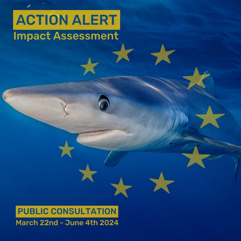 forward movement for the #StopFinEU campaign to end the fin trade in Europe! And this time ANYONE can take action for sharks. All you need is 5 minutes to make a massive impact, here's how...
At this stage the European Commission is accepting public comments via their official questionnaire. This is your opportunity to participate, deadline is June 4th 2024. The questions are focused on policy options. These are loaded questions, so be very careful and read the details below before you begin. This is completely about your opinion, any suggestions we make below are simply that, suggestions. Click the links below if you want to see how Shark Allies answered. To participate, go to this link and create a log in. Here are some overall points that might help you understand and navigate the process: For each question you have six option ranging from VERY POSITIVE to VERY NEGATIVE and NO OPINION. Be aware that the Commission will most likely just tally the results automatically and not carefully consider subtleties you want to express. It’s probably best to be very obvious in your selection. NEUTRAL is a better choice than NO OPINION to show that there is most likely no impact, or there will be negative and positive changes that will balance out. When you read the proposed policy options (#2-7) please keep in mind that they are not asking whether these are good practices to pursue in general (most of them are), but whether this is the one policy solution they should chose (instead of a fin trade ban). So your answers should reflect whether that particular policy option will bring the effect you desire. If you are in favor of a fin trade ban, then policy options #2-5 are completely undesirable, since they would not create any effective change. At best they would be NEUTRAL. Therefore, the environmental impacts would be VERY NEGATIVE (because very little would change and systems keep degrading) and most of the social and economic impacts would be NEUTRAL, because they wouldn’t change much from what they are now (with the exception being tourism and human health). You will see why, as you read on. For guidance on the questionaire in multiple languages, you can follow along at the link below: https://sharkallies.org/eu-action Signed the Open Letter urging WHO to prioritize spillover prevention in the Pandemic Agreement!16/3/2024
Merman Conservation Expeditions Ltd proudly stands alongside fellow conservation advocates to sign the open letter urging WHO to prioritize spillover prevention in the Pandemic Agreement! 📜 At the heart of the issue lies the need to address drivers of zoonotic disease emergence, notably wildlife trade & markets. 🐾 Despite fading from public discourse, the risk remains high: 1.7 million viruses could infect humans, emphasizing the need for proactive measures. 🦠 CITES addresses wildlife trade impact on species survival, but not the health risks to humans or animals. We need a more comprehensive approach! 🐒🦇 Investing in primary prevention now can save huge costs in the long run, as demonstrated by the mere 2% of expenses during COVID-19 spent on prevention efforts. 💰 It's time for governments to take decisive action to reduce the risk of future pandemics and protect current & future generations. 🌏 We urge the WHO to heed scientific advice and prioritize spillover prevention, including regulating wildlife trade & markets, in the Pandemic Agreement. 📢 Let's work together to safeguard global health! 🤝 #PandemicPrevention #WildlifeTrade #WHOAgreement 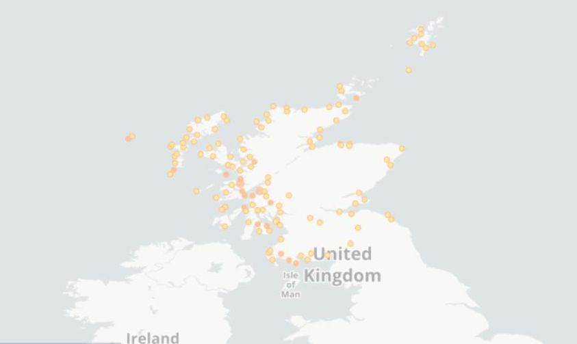 Scotland's coastal waters are teeming with elasmobranchs, including sharks and rays! From the majestic Basking Shark to the mysterious Common Skate, these marine wonders play a vital role in our ecosystem.
Have you ever spotted one during your seaside adventures? Share your elasmobranch encounters (https://www.inaturalist.org/projects/sharks-in-scotland) or tag a friend who loves marine life! Let's celebrate the diverse and fascinating world beneath the waves. #Elasmobranchs #ScotlandMarineLife #OceanWonders #BiodiversityDiscovery Introduction:
In September 2023, Thessaly, Greece, witnessed unprecedented floods that not only reshaped its terrestrial landscape but also had a profound impact on the coastal underwater ecosystems. This article explores the aftermath of the great floods, examining the transition from a rocky substrate to mud and evaluating the consequences for marine species. Additionally, it delves into the essential steps needed for future wildlife research and how individuals can contribute to the understanding and preservation of these fragile ecosystems. The Before Picture: Before the floods, the coastal underwater environment of Thessaly boasted a diverse and thriving ecosystem. Rocks provided a sturdy substrate, offering habitat for various marine organisms such as algae, mollusks, crustaceans, and small fish. The rocky surfaces were not only a source of shelter but also a platform for the attachment of sessile organisms like barnacles and corals. It was a vibrant and balanced underwater community. The Flood Impact: The massive floods in September 2023, triggered by intense rainfall and natural factors, left a lasting imprint on the coastal underwater landscape of Thessaly. The force of the floodwaters eroded the rocky substrate, dislodging rocks and reshaping the seabed. The once stable and rocky environment gave way to a softer, more malleable substrate sand and soil/mud. Shift to Mud Substrate: As the floodwaters receded, a layer of sediment settled on the seabed, transforming the once rocky substrate into a muddy environment. This shift had significant implications for the underwater flora and fauna of Thessaly. The mud substrate presented new challenges and opportunities for marine life that had adapted to the previous rocky environment. Impact on Marine Flora: The transition from rocks to mud had a notable impact on marine flora. Algae, accustomed to attaching to rocky surfaces, faced challenges in securing themselves to the muddy substrate. While some algae species adapted to the new conditions, others struggled to establish themselves, leading to shifts in the underwater plant life and impacting overall biodiversity. Changes in Fauna Distribution: The alteration of the substrate triggered a redistribution of marine fauna. Species adapted to rocky surfaces had to adjust to the softer mud substrate. Mobile organisms such as crabs and certain fish navigated the change more effectively, while sessile organisms like barnacles faced challenges in finding suitable attachment points. Adaptations and Challenges: The underwater wildlife system in Thessaly showcased remarkable adaptability. Some species evolved to exploit the new opportunities presented by the mud, while others faced challenges in finding suitable habitats and food sources. The delicate balance of predator-prey relationships and competition for resources underwent a period of adjustment as the ecosystem sought a new equilibrium. Examples of Species Impact: Endangered Species: a. Barnacles and Corals: Sessile organisms like barnacles and certain coral species that rely on rocky surfaces for attachment may face challenges in the mud. Reduced attachment points and difficulty obtaining nutrients from the sediment could endanger these species. b. Rock-dwelling Fish Species: Fish adapted to rocky habitats may find it difficult to adjust, affecting populations and the local food web. c. Certain Algae Species: Algae specialized for rocky surfaces may struggle to establish themselves on the muddy substrate, impacting herbivores dependent on them for food. Thriving Species: a. Crabs and Burrowing Organisms: Mobile species may thrive in the mud, utilizing the soft sediment for burrowing and shelter. b. Opportunistic Algae and Seagrasses: Some algae and seagrass species adaptable to different substrates may thrive in the nutrient-rich mud. c. Generalist Fish Species: Fish species with flexible habitat preferences may adapt more easily to the shift, experiencing population increases. Migration and Colonization: a. Migratory Species: Changes in migration patterns may occur as species move to areas with more suitable substrates, impacting regional biodiversity. b. Colonization by New Species: The mud substrate may attract new species adapted to such environments, contributing to overall ecosystem resilience and diversity. What Needs to Be Done Tomorrow: Understanding the evolving dynamics of Thessaly's underwater ecosystems is crucial for effective conservation and management strategies. Tomorrow's wildlife research should focus on:
How You Can Contribute: Individuals can play a crucial role in supporting ongoing research and conservation efforts:
|
IntroFrom conservation initiatives to groundbreaking research, our blog is your portal to the awe-inspiring world of wildlife conservation. Archives
July 2024
Categories
All
|


 RSS Feed
CompanyMerman Conservation Expeditions LTD
Company Number SC787239
|
ContactEmail: [email protected]
Telephone: +44 (0) 7475353130 (UK) +30 6945927483 (Greece) Working Hours: M-F: 10am - 18pm (London Time) |
|
Copyright © 2023 Merman Conservation Expeditions Ltd. All rights reserved.
|